
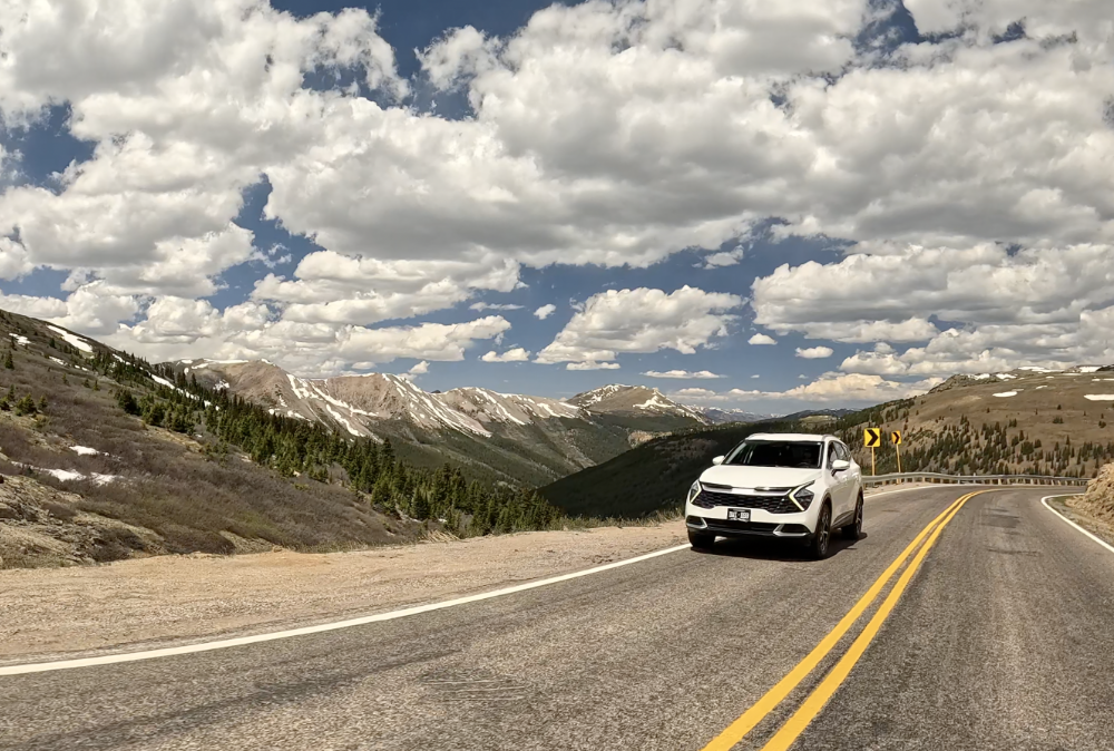
There are Colorado drives where the road is simply how you get somewhere.
Independence Pass is not one of them.
From Twin Lakes, Colorado Highway 82 leaves the broad Upper Arkansas River Valley and climbs into the heart of the Sawatch Range, passing forests, rushing creeks, alpine tundra, old mining country, waterfalls, ice caves, and some of the biggest mountain scenery in Colorado.
The summit sits at 12,095 feet on the Continental Divide, only about 18 miles west of Twin Lakes. But mileage is a poor way to measure this trip. With stops at the summit, the Independence ghost town, the Grottos, and perhaps Aspen, it can easily become one of the best full-day adventures from the Arkansas River Valley.
If you are staying in Leadville, Buena Vista, Nathrop, or Salida, here is how to make the most of it.
Start at Twin Lakes
Twin Lakes is the natural eastern starting point for an Independence Pass drive.
Before turning onto Highway 82, spend a little time around the lakes themselves. The enormous reservoirs sit beneath the Sawatch Range with Mount Elbert and other high peaks rising dramatically nearby.
It is easy to treat Twin Lakes as nothing more than a highway junction, but it deserves better than that.
Walk around the historic village, stop near the water, take in the mountain views, or simply grab a few photos before heading west.
From here, Highway 82 follows Lake Creek and begins climbing steadily into the mountains.
If you are exploring more of the Upper Arkansas Valley, also check out the Arkansas River Guide to Leadville and our Buena Vista guide.
Enjoy the Climb Instead of Racing to the Summit
The east side of Independence Pass feels like a gradual transition into another world.
Open valley gives way to forest. Mountains close in around the road. Lake Creek runs nearby, and the terrain becomes steeper and more dramatic as you gain elevation.
Eventually the trees begin to thin and the landscape opens into alpine tundra.
This is part of the Top of the Rockies Scenic and Historic Byway, and the drive itself is the attraction.
There are places to pull off and enjoy the scenery, but use established pullouts. Highway 82 is narrow in places, cyclists regularly ride the pass, and blind corners are common.
There is no reason to hurry.
You are not just driving to Independence Pass. You are driving Independence Pass.
Reach the Continental Divide at 12,095 Feet
The summit is the high point of the trip, literally.
At 12,095 feet, Independence Pass crosses the Continental Divide between the Arkansas River watershed to the east and the Roaring Fork and Colorado River watersheds to the west.
There is parking near the summit and a short walk through the alpine landscape to viewpoints.
Even if it feels hot in Buena Vista or Salida, bring another layer. Temperatures and weather can be dramatically different at 12,000 feet, and summer thunderstorms can develop quickly in Colorado’s high country.
Take your time walking around if you are not accustomed to the elevation. A short stroll at 12,000 feet can feel surprisingly different from walking around town.
Most importantly, stay on established paths and durable surfaces. Alpine tundra has an extremely short growing season and can be damaged by repeated foot traffic.
Once you have explored the summit, you have a decision to make.
You can return toward Twin Lakes, or continue west toward Aspen.
Continuing west adds some of the best stops on the entire route.
The Independence Ghost Town Is West of the Divide
If you continue toward Aspen, the historic townsite of Independence is one of the first major stops.
This is an important geographical distinction: the ghost town is not on the Twin Lakes side of the pass. It sits about three miles west of the Continental Divide on the Aspen side.
Independence grew during Colorado’s mining boom after prospectors arrived in the area in the late 1870s. At its peak, the isolated mountain settlement supported miners, businesses, cabins, mills, and other structures at an elevation of more than 10,000 feet.
The boom did not last.
Today, surviving structures and ruins sit in a spectacular alpine valley beside Highway 82.
It is a great place to stretch your legs because the stop adds something completely different to the drive. Independence Pass suddenly becomes more than scenery. You get a glimpse of how ambitious, difficult, and sometimes absurd mountain settlement could be in the late 1800s.
Give yourself enough time to walk through the site rather than simply looking at it from the road.
Stop at the Grottos
Continue down the western side of the pass and the landscape changes again.
Roughly nine miles east of Aspen is the Grottos, one of the easiest stops to miss and one of the most interesting places along Highway 82.
A short trail from the day-use area leads through sculpted rock formations beside the Roaring Fork River, including waterfalls and the well-known Grottos ice caves.
The geology here is fun to explore even if you are not particularly interested in geology.
Water has carved and polished the rock into channels, bowls, slots, and smooth formations that look very different from the broad alpine landscape at the summit.
The ice caves can retain ice surprisingly late, although conditions vary throughout the year. Rocks around the caves and river can also be slick, so use some judgment, particularly with younger kids.
The Grottos works especially well on an Independence Pass road trip because you do not need to commit to a long hike. You can stop, explore for a while, have a picnic, and continue toward Aspen.
It also marks another major change in the trip. By this point you have followed the headwaters of Lake Creek up the east side of the Continental Divide and are now descending alongside the young Roaring Fork River toward Aspen.
Should You Continue to Aspen?
If you have the time, absolutely consider it.
Aspen is only a short drive beyond the Grottos, and reaching town gives the road trip a satisfying destination before you turn around.
You do not need to turn an Independence Pass outing into an elaborate Aspen vacation. Park, walk around downtown, grab lunch or coffee, explore a few blocks, and enjoy the change of scenery.
Aspen feels very different from Leadville, Buena Vista, or Salida, which is part of what makes the trip interesting.
In one day, you can go from the Arkansas River Valley through tiny Twin Lakes, cross the Continental Divide above 12,000 feet, explore a mining ghost town and ice caves, and end up walking around one of Colorado’s best-known mountain towns.
If you plan to spend a few hours in Aspen, check current parking information before arriving. Summer weekends can be busy.
Then retrace the entire route back toward Twin Lakes.
The scenery looks surprisingly different in the opposite direction.
Know the Vehicle Restrictions Before You Go
Independence Pass is paved, but it is not an ordinary mountain highway.
Some sections on the Aspen side are extremely narrow and require drivers to slow down or yield to opposing traffic.
Colorado Department of Transportation rules prohibit vehicles or vehicle-and-trailer combinations 35 feet or longer from using the restricted portion of Highway 82 over Independence Pass.
That matters if you are visiting the Arkansas River Valley in an RV or towing a camper.
Leave the large rig at your campground and make the drive in a smaller vehicle.
Even in a normal passenger vehicle, expect sharp curves, steep grades, cyclists, occasional rockfall, and places where paying attention matters more than enjoying the view.
Save the sightseeing for the pullouts.
Before leaving, check the current Independence Pass information from the Colorado Department of Transportation and current road conditions before heading into the high country.
How to Build an Independence Pass Day
One of the best things about this drive is how easily it fits into a larger Arkansas River Valley trip.
From Leadville
Start early in Leadville and drive south toward Twin Lakes.
Spend some time around the lakes, drive to the summit, then continue west to Independence, the Grottos, and Aspen if time allows.
Return over the pass and finish the evening back in Leadville.
It makes for an unusually varied Colorado day: historic mining town, enormous lakes, alpine tundra, ghost town, mountain river, and the Continental Divide.
From Buena Vista or Nathrop
Buena Vista and Nathrop are excellent bases for this drive.
Head north on Highway 24 toward Twin Lakes in the morning, cross Independence Pass, and choose how far west you want to go.
A summit-only trip can work as a half-day outing.
Adding Independence and the Grottos makes it much more interesting.
Adding Aspen turns it into a full-day road trip.
Back in the Arkansas Valley, you can finish the day with dinner in Buena Vista or a hot-springs soak around Chalk Creek.
Browse the Arkansas River Guide hot springs guide for more ideas.
From Salida
From Salida, Independence Pass is a longer outing, but it is completely reasonable as a full-day trip.
Leave early and follow Highway 24 north through Buena Vista toward Twin Lakes.
On another day, keep things closer to your basecamp and explore Salida itself, Browns Canyon, local trails, or the river.
Our Salida visitor guide has plenty of ideas for building the rest of the trip.
Pair Independence Pass With an Arkansas River Day
Independence Pass is even better when it is not the only reason you came to the area.
Spend one day in the high country and another along the Arkansas River.
Depending on your interests, that could mean rafting Browns Canyon, fishing, mountain biking around Salida or Buena Vista, hiking, soaking in hot springs, camping beside the river, or simply exploring the towns along Highway 24.
If rafting is part of the trip, start with our guide to rafting the Arkansas River to compare different sections of the river and find the experience that fits your group.
This is what makes the Upper Arkansas River Valley such a good basecamp.
You do not have to choose between a river trip and a mountain road trip.
You can do both.
Late Summer Is a Great Time to Drive Independence Pass
Independence Pass is a seasonal highway.
Snow closes the road during winter, with the highway typically reopening in late spring when conditions allow.
By late summer, the road is usually well into its operating season, and August is a particularly good time to combine the pass with rafting, hiking, camping, fishing, and other Arkansas River Valley activities.
September can be even more spectacular as autumn colors begin appearing in the high country.
Just remember that elevation makes its own rules.
A sunny afternoon in Buena Vista does not guarantee good weather at 12,095 feet.
Check conditions on the day you go.
A Few Things to Bring
You do not need expedition equipment to drive Independence Pass, but a few things make the day better:
- A warm layer, even on a hot summer day
- Drinking water
- Sunscreen
- Comfortable walking shoes
- A camera or phone with plenty of storage
- Snacks or a picnic
- A full enough gas tank that fuel is not part of the adventure
- An offline map in case cell coverage becomes unreliable
Most importantly, bring enough time.
Trying to blast over the pass, take one summit picture, and immediately turn around misses the point.
The Best Part Is Everything Between Twin Lakes and Aspen
The summit gets the attention, but Independence Pass is really a collection of landscapes and places tied together by one remarkable road.
Twin Lakes introduces the high country.
The east side climbs from the Arkansas River watershed into the Sawatch Range.
The summit crosses the Continental Divide at more than 12,000 feet.
On the west side, the Independence ghost town tells part of Colorado’s mining story.
The Grottos brings you down beside the young Roaring Fork River through waterfalls, rock formations, and ice caves.
And Aspen gives you an entirely different mountain town at the end of the road.
You can drive the whole thing in a few hours.
You probably shouldn’t.
Take the day.
Stop often.
And remember that on Independence Pass, getting there is most of the reason to go.
Frequently Asked Questions
Is Independence Pass open right now?
As of August 10, 2026, Independence Pass is open for the summer season. Conditions can change because of weather, rockfall, or maintenance, so check current road conditions immediately before your drive.
How high is Independence Pass?
The summit of Independence Pass is 12,095 feet above sea level.
Where are the Grottos?
The Grottos are on the western, Aspen side of Independence Pass, roughly nine miles east of Aspen on Highway 82. Short trails lead from the day-use area to rock formations, waterfalls, and ice caves.
Can I drive an RV over Independence Pass?
Vehicles and vehicle-and-trailer combinations 35 feet or longer are prohibited on the restricted portion of Independence Pass. Even smaller RVs should be driven cautiously because of extremely narrow sections and tight curves.
Is it worth driving all the way to Aspen?
If you have a full day, yes. Aspen makes a natural turnaround point and gives you a chance to walk around town, eat lunch, or take a break before driving back over the pass. If you are short on time, the summit alone makes a good half-day trip, while adding Independence and the Grottos makes the drive much more rewarding.
Keep Exploring the Upper Arkansas
Independence Pass is only one piece of the headwaters country.
Use Arkansas River Guide to explore Leadville, Twin Lakes, Buena Vista, Browns Canyon, Salida, rafting, fishing, camping, hot springs, scenic drives, and the river that connects them all.